Frontier mining,
engineered.
Aremis finds, proves and mines gold in Africa's under-explored gold belts, combining modern geoscience, integrated data and disciplined, staged development.
The next mines are hidden.
The world needs new gold mines, and the easy ones have been found. The next generation of deposits lies where the geology is hidden, the data is thin and the ground is hard to read. That is where we work.
Frontier mining is the discipline of turning under-explored ground into producing mines. It demands three things at once: the science to see beneath the surface, the engineering to build in remote places, and the patience to do it in stages.
Read our approach →Five stages. Each one has to earn the next.
Exploration is a series of decisions under uncertainty. At every stage we ask what the evidence shows and which test would change the decision. The expensive tests are kept for the ground that has earned them.
- 01~1,000 km
Belt
Why could a gold system exist here?
- Inputs
- Tectonic setting, published maps, regional geophysics
- Output
- Belts with a coherent geological case
GATEA deposit model that fits
- 02~100 km
Corridor
Where could the fluids have been trapped?
- Inputs
- Satellite imagery, elevation, magnetics, structural interpretation
- Output
- Corridors ranked for ground work
GATEStructures consistent with the model
- 03~10 km
Target
What supports the model, and what contradicts it?
- Inputs
- Field and regolith mapping, soil and auger geochemistry, ground geophysics
- Output
- Targets ranked, unknowns stated
GATECoincident, explained anomalies
- 04~1 km
Resource
How much gold, how continuous, how recoverable?
- Inputs
- RC and diamond drilling under QA/QC, density, metallurgical testwork
- Output
- A resource signed by an independent Competent Person
GATEA resource that supports a mine plan
- 05~10 m
Mine
Does the model hold in the pit?
- Inputs
- Staged pit design, grade control, monthly reconciliation
- Output
- Refinery-certified gold, and data for the next target
FEEDBACKPit results return to the model
Explore
From the belt to the drill target: remote sensing, structural mapping, geochemistry and geophysics, tested in the field.
Exploration →Prove
From the drill hole to a resource: QA/QC-controlled drilling, 3D geological models and geostatistical estimates, signed by independent Competent Persons.
Technology →Mine
From the resource to gold: staged development, from near-surface material to fresh rock, each phase funding the next.
Mining →One company, the whole chain.
Most companies stop at one link of the chain. Explorers sell discoveries. Investors fund them. Operators build what others found. Aremis holds the whole chain, so that what we learn in the pit feeds the next drill hole, and what we learn in the drill hole shapes the mine.
Evidence first. Capital follows. Production proves.
Every ounce we produce is weighed, assayed and certified by the refinery, and our production figures are independently audited.
What we report is what we pour.
From satellite to smelter: one data chain.
Africa's gold provinces.
From the Birimian belts of West Africa to the Lake Victoria goldfields, the Zimbabwe craton and the Arabian-Nubian Shield, Africa holds some of the world's richest gold terrains. Much of that ground has never been tested below surface cover. That is the ground we work on.
See our region →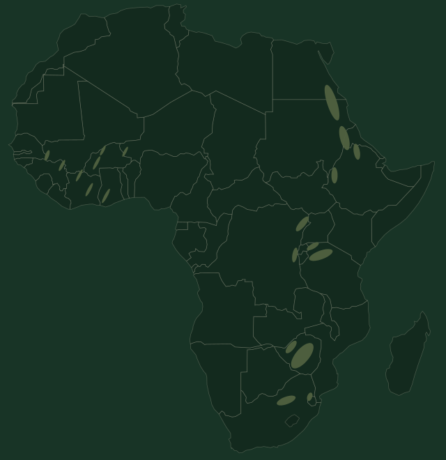
Compliance before everything.
Mining code
We operate within each country's mining code and disclose our ownership to the competent authorities.
Local partners
Local employment, local suppliers and training are built into every phase of the plan.
Responsible gold
OECD due diligence, every shipment traced from mine to refinery, no third-party gold.
Independent by design
Every resource we report is signed by an independent Competent Person.
Let's talk about ground, capital or technology.
Governments and state partners
A long-term partner working within the Mining Code, committed to local employment and skills.
Talk to us →Licence holders and operators
If your ground has a sound geological case, we bring the programme, the capability and the route to production.
Propose a project →Investors and technical partners
Drilling, laboratories, engineering, equipment, technology and capital.
Work with us →